
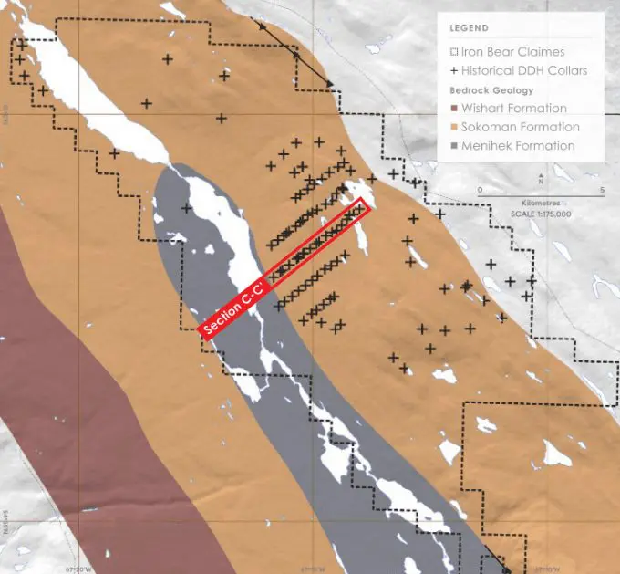
Iron Bear is situated in the Churchill Province of the Proterozoic Labrador Trough, which extends for more than 1,100 km along the eastern margin of the Superior Craton from Ungava Bay to Lake Pletipi, Québec (Figure 1).
Since acquisition in April 2023, CLE has commissioned metallurgical testing of drill core obtained by previous operators in 2011 and 2012 drilling campaigns and stored on site. At the same time, information from these drilling campaigns has been used to support detailed reinterpretation of geophysical data and historical mapping using modern modelling techniques.
Category | Tonnes (Billion) | Total Fe % | Magentic Fe % |
Indicated | 4.5 | 29.46 | 20.6 |
Inferred | 9.1 | 30.31 | 20.73 |
Total | 13.6 | 30.03 | 20.68 |
Exploration Target | |||
From | 16 | 24 | 16 |
To | 21 | 33 | 22 |
Iron Bear’s Mineral Resource estimate is based on data collected by CapEx Mining Ltd and modified by detailed compilation and interpretation of high-resolution geophysics and geology. Iron mineralisation mainly consists of magnetite (Fe3O4) and haematite (Fe2O3).
This is the innovative factor that Iron Bear Resources has brought to this project – there was ample information within the database to estimate a Mineral Resource with confidence in geological and grade continuity, but the data had not been adequately compiled and analysed. Most importantly Iron Bear Resources commissioned the development of an inversion model which demonstrated an excellent correlation between the high-grade magnetic survey, the drilling results, down hole magnetic susceptibility data and provided reliable estimates of the mineral resource volumes. This aspect, coupled with the identification of real infrastructure solutions and outstanding metallurgical results satisfy the confidence required of an Indicated Mineral Resource within the provisions of the JORC Code.
Iron Bear hosts Lake Superior-type banded iron formation comprising magnetite and haematite within chert, with variable amounts of silicate, carbonate and sulphide. Fresh, unaltered units are referred to as taconite and comprise bands of magnetite and/or hematite with grey chert or jasper.
Iron Bear was the focus of a 2011 and 2012 drilling programme that identified mineralisation in what was named the Greenbush Zone. It is approximately 10 km long, striking northwest-southeast and 5 km wide and encompasses the Mineral Resource estimate. Numerous thrust faults have stacked mineralised geological units to greater than 500 vertical metres.
The mineralogy and grade are uniform throughout the fault slices and the same overall group of sub-members is repeated in whole or in part. The limits of the Greenbush Zone are open, and it is defined by a combination of mapping, geophysics, and drilling density in the Mineral Resource area.
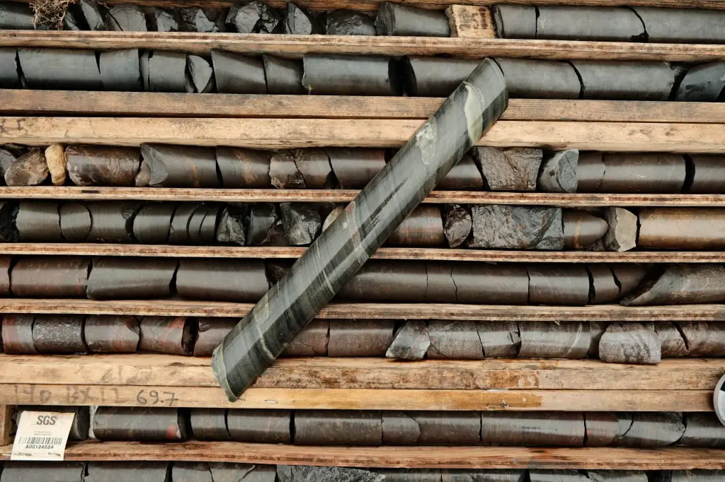
Previous explorers conducted mapping, geophysical surveys, and diamond drilling. In 2011 this comprised 43 drill holes for 5,662 m and in 2012, drilling of 72 drillholes for 22,359 m. This drilling was completed along grid lines 500 m to 600 m apart. The distance between holes varied, often less than 200 m apart. The drilling covered an approximate NW-SE strike length of 4 km by 2.5 km and tested mineralisation to a vertical depth of approximately 450m.
The results of this work were used to estimate a historic mineral resource of 7.2 billion tonnes of iron mineralised material at a total iron content (FeTOT) of 29.2% and magnetically separable iron content (MagFe) of 18.9% by mass, as determined by Davis Tube test work.
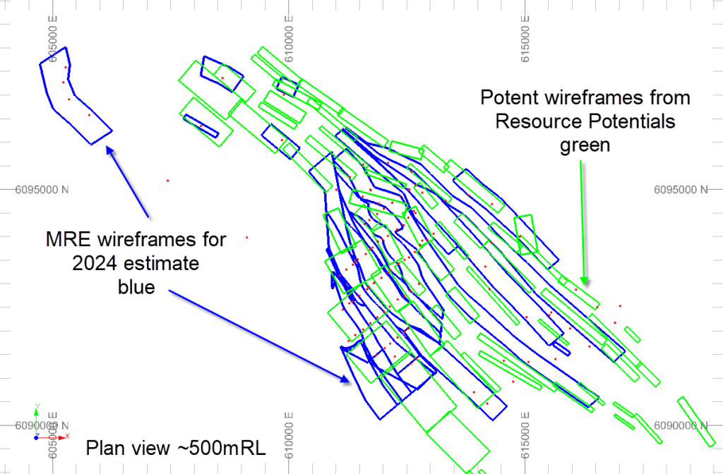
CLE commissioned Resource Potentials Pty Ltd, consulting geophysicists, of Perth (ResPot), to validate, compile and reinterpret the existing database of historic geological mapping and geophysics and more modern geophysical data, including detailed aerial magnetic surveys, down hole geophysics and gravity surveys.
Despite the large volume of valid data, this exercise had not been previously and comprehensively undertaken.
This exercise indicated that the geophysical and mapping data align consistently with the drilling data at the deposit scale. This allowed detailed reinterpretation of the location of and deportment of mineralisation within the Sokoman sequence. Inversion models of the shapes of this mineralisation were than generated and verified against the mapped outcrop of mineralisation and the extensive historic drilling. These shapes were then used to constrain a mineralisation estimate.
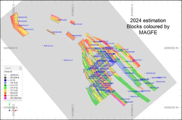
Blocks of 20mx by 100my by 20mz were constructed and oriented along the strike of the mineralisation using a dynamic rotation algorithm, governed by the geometry of the thrust faults identified in drilling and the ResPot compilation data.
Interpolation parameters were modified from those used in the 2013 Mineral Resource estimate to create a smoother result that honours the sample data, which was composited to 3m intervals. A search ellipse of 1,750mx by 300my by 50mz was imposed, based on the results of geostatistical analysis of the database. A minimum of five and maximum of twenty composites were included per drill hole.
The mineralisation has been stacked by folding and low angle thrust faulting into a series of inclined imbricate slices, which were used as hard boundaries for the interpolation.
Fe2O3, Fe3O4, haematite and magnetic iron oxide were populated by regression equations in the same manner as for the 2013 estimation, as was bulk density in mineralised sections: Bulk density = (FeTOT x 0.0279) + 2.5695
Bulk density was set as 1.9 t/m3 for overburden and 2.9 t/m3 for unmineralised material.
Overburden was flagged using the topography wireframe translated down five metres down at null grade and examination of subcelled cross sections indicates that this has negligible effect.
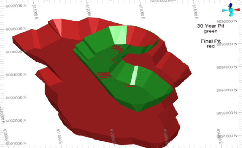
Two pit shells were used for classification of the Mineral Resource, CapEx’s “30-year” pit shell, which was used to support its PEA’s; and CapEx’s “ultimate” pit shell:
Iron Bear Resources is planning a drilling program for approval by the Newfoundland and Labrador Geological Survey. This program is designed to test the Exploration Target by reverse circulation drilling of magnetic lithology defined by the ResPot inversion model. Samples will be taken to verify grade and metallurgical characteristics. The program is planned to be completed by June 2025 or earlier subject to approvals and funding.
The Mineral Resource estimate is reported for all relevant assayed elements and the Competent Person notes that deleterious elements are relatively low when compared to other deposits in the Labrador Trough (Table 2).
No estimation had been performed for other elements for the Exploration Target, which is reported at a 10% MagFe cut-off. This cut-off appears to be a natural geological cut-off in the data and demonstrates low statistical sensitivity.
Classification 12.5% MagFe cut-off | Volume Bm3 | Bulk Density (p) | Tonnes (Bt) | %By Mass | |||||||||
MagFe | Fetot | Mn | SiO₂ | K2O | LOI | MgO | MnO | Na2O | P | ||||
Indicated | 0.64 | 3.37 | 2.15 | 18.97 | 28.68 | 0.53 | 46.12 | 0.06 | 6.94 | 2.49 | 0.69 | 0.03 | 0.03 |
Inferred | 4.28 | 3.39 | 14.51 | 18.13 | 29.44 | 0.52 | 45.75 | 0.08 | 4.83 | 2.22 | 0.67 | 0.03 | 0.03 |
Total | 4.92 | 3.39 | 16.66 | 18.24 | 29.34 | 0.52 | 45.8 | 0.08 | 5.1 | 2.26 | 0.67 | 0.03 | 0.03 |
Exploration Target | 16 | 16 | 29 | ||||||||||
(10% MagFe cut-off) | 21 | 22 | 30 | ||||||||||
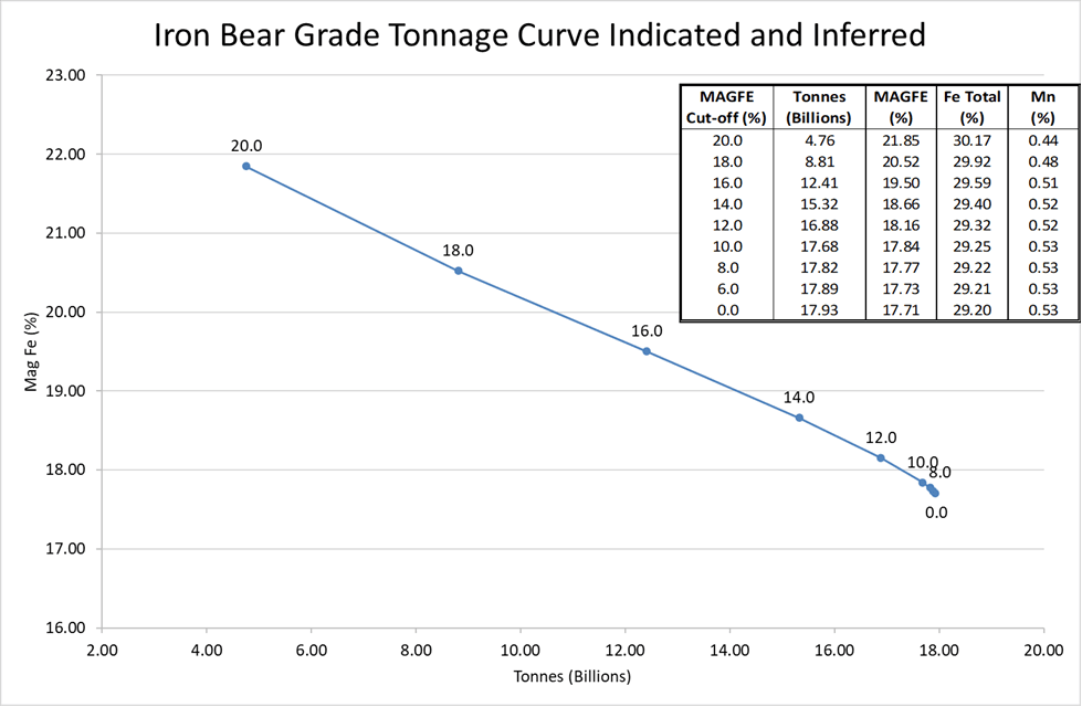
The tonne-grade curve for the Iron Bear Mineral Resource estimation is remarkably consistent, showing a gradational distribution of mineralisation, with a natural lower cut-off of around 10% MagFe.
The JORC Code definition of a Mineral Resource requires “reasonable prospects for eventual economic extraction”. In June 2013, Cap-Ex published (on the TSX) a NI-43101 compliant PEA (Preliminary Economic Study1) which returned a positive result.
The PEA contemplated the construction of a magnetite concentrator and pelletising plant adjacent to the mine pit and then railing the product to port via the existing railway. In 2020 the PEA was updated by Hatch Ltd2, consulting engineers of Canada, and delivered positive technical and economic outcomes.
Iron Bear Resources completed additional metallurgical test work leveraging a custom designed industrial pilot plant which indicates that the Iron Bear project can produce higher quality magnetite products at a higher yield than that contemplated by Cap-Ex and Hatch. This further reinforces the likelihood that there are reasonable prospects for economic exploitation of the Iron Bear mineral resource. In addition, Iron Bear Resources is actively investigating technical solutions to reduce the environmental footprint of the mining operations – and has specifically designed a ‘dry tailings’ mining operation which will mitigate any impact on the lacs and aquifers.
The key factors which are expected to underpin the economic viability of a potential mineral extraction are:
Large and relatively homogeneous mineral resource amenable to open pit mining.
Low stripping ratio, with negligible overburden.
Favourable grindability indices of BWi = 16.7 kWh/t and SMC = 11.7 kWh/t.
Location less than 25 km from existing open access heavy haul railway connected to an open access iron ore export port.
Access to low-cost regional hydropower.
Very low deleterious elements.
Dry tailings mining operation (no tailings dam).
Iron Bear Resources has utilised the optimised pit shells from the 2013 and 2020 PEA work to evaluate the 2024 Mineral Resource estimate for reasonable prospects for eventual economic extraction. The parameters applied to the earlier optimisations are broadly similar to those contemplated today and the Competent Person considers that the resultant pit shells are not materially different. Iron Bear Resources will be performing its own optimisations as part of its project development.